
The Sykes-Picot Agreement divided Ottoman Middle Eastern territories into five zones. France received the "Blue Zone" (direct control over coastal Syria and Lebanon) and "Zone A" (influence over inland Syria). Britain got the "Red Zone" (direct control over southern Mesopotamia including Baghdad and Basra) and "Zone B" (influence over Transjordan and northern Mesopotamia). The "Brown Zone" around Jerusalem and Palestine was designated for international administration (Russia, Britain, and France), and Russia was promised Constantinople and the Turkish Straits.
These artificial boundaries, drawn without regard for ethnic or religious populations, created modern Iraq, Syria, Lebanon, and Jordan, fundamentally reshaping Middle Eastern geopolitics.

The Sykes-Picot Agreement of 1916 stands as one of history's most consequential yet controversial diplomatic arrangements, fundamentally reshaping the Middle East through a series of artificial boundaries that continue to influence regional geopolitics more than a century later. Negotiated secretly between British diplomat Mark Sykes and French diplomat François Georges-Picot during World War I, this agreement represented the Allied powers' vision for dismantling the Ottoman Empire and dividing its Middle Eastern territories among European colonial powers, with profound implications for the future of Palestine.
The agreement established a complex five-zone system that reflected European imperial ambitions rather than regional realities. France secured two distinct areas of control: the "Blue Zone" granted direct French administration over coastal Syria and Lebanon, regions that would provide strategic Mediterranean access and economic opportunities. Additionally, France received "Zone A," encompassing inland Syria, where French influence would predominate while allowing for some degree of local autonomy under French oversight.
Britain's territorial allocation was equally strategic, reflecting its imperial priorities in securing routes to India and controlling vital oil resources. The "Red Zone" placed southern Mesopotamia, including the crucial cities of Baghdad and Basra, under direct British control, ensuring access to emerging petroleum reserves and maintaining communication lines with British India. "Zone B" extended British influence over Transjordan and northern Mesopotamia, creating a buffer zone that would protect British interests while providing territorial continuity across the region.
The treatment of Palestine proved particularly significant for the territory's future development. The "Brown Zone," encompassing Jerusalem and Palestine, was designated for international administration involving Russia, Britain, and France. This arrangement reflected the area's unique religious significance to Christianity, Islam, and Judaism, while also serving the practical purpose of preventing any single power from controlling the strategically located territory. The international status was intended to balance competing European interests while acknowledging Palestine's special character.
Russia's promised compensation included Constantinople and the Turkish Straits, reflecting the agreement's broader scope beyond Arab territories. However, the Russian Revolution of 1917 would ultimately nullify these provisions, dramatically altering the agreement's implementation.
The Sykes-Picot boundaries were drawn with striking disregard for existing ethnic, religious, or tribal populations, creating artificial nation-states that grouped diverse communities together while separating related peoples. This approach laid the foundation for modern Iraq, Syria, Lebanon, and Jordan, but also created enduring tensions and conflicts. The agreement's legacy in Palestine would be further complicated by the subsequent Balfour Declaration and the eventual British Mandate, which introduced additional layers of complexity to an already volatile situation.
The arbitrary nature of these boundaries continues to influence Middle Eastern politics, contributing to regional instability and conflicts that persist today.
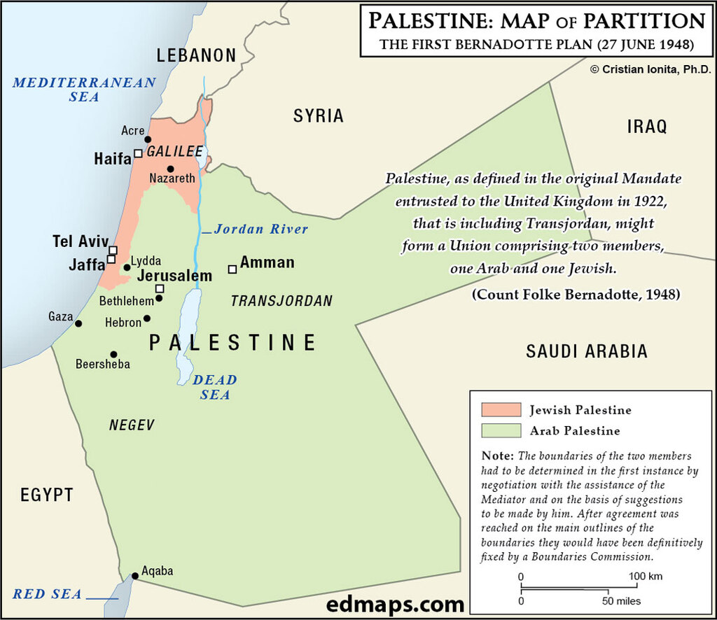
Count Bernadotte's June 1948 plan proposed a Palestine-Transjordan union with two autonomous members, one Arab and one Jewish, controlling their own affairs.
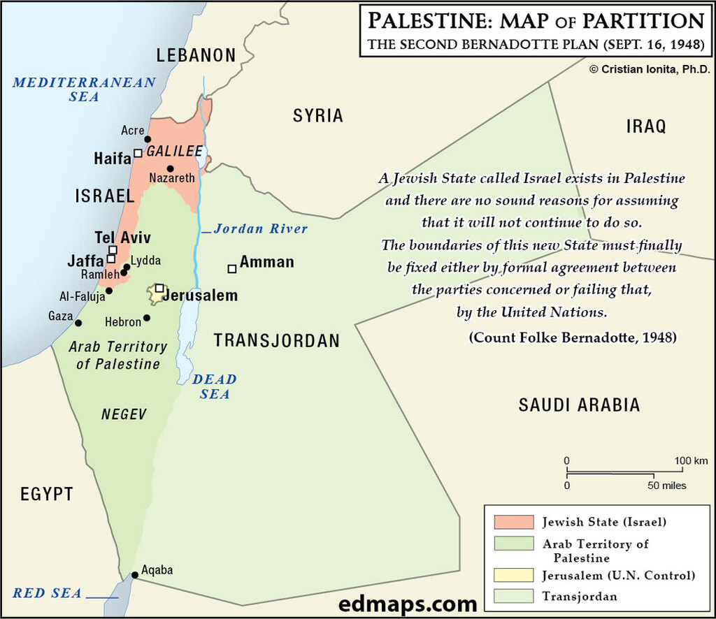
According to the new Count Bernadotte's September 1948 plan, Israel cedes Negev to Arabs and gains Galilee, with Jerusalem becoming an international city.
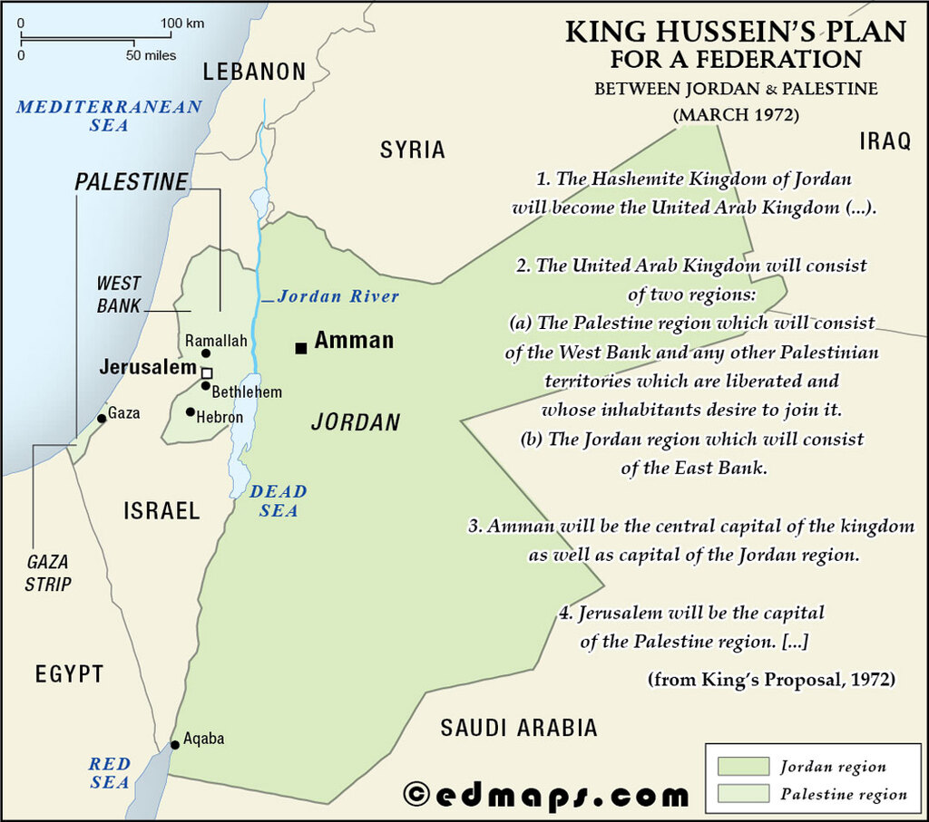
King Hussein's 1972 "United Arab Kingdom" plan merged West Bank (Arab Palestine) with Jordan within a Hashemite federation.
